
Manifold Valley Trail Centre to Roche Grange
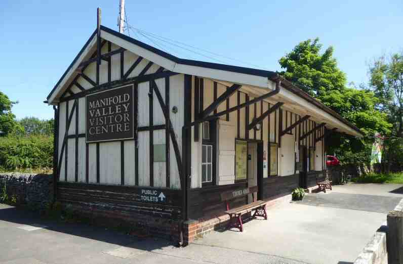
MANIFOLD VALLEY TRAIL CENTRE (Hulme End on the Warslow to Hartington Road – SK103593)
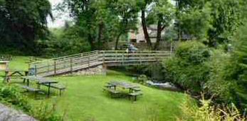
The impressive Manifold Valley Visitor Centre is situated at the northern end of the Manifold Track, a favourite for walkers, cyclists and horse riders. It is housed in the ticket office of the former Hulme End Station. There is a permanent exhibition of the history of the railway and information about the Manifold Valley. The Tea Junction offers food and refreshments in a café that has been tastefully constructed to resemble the former engine shed. There is a car park, picnic tables, fully accessible toilets and a cycle hire centre.
MEERBROOK (off the A3 Leek to Buxton road – SK989608)
A small village, Meerbrook is on the southwestern edge of the Peak District, set in a beautiful location, surrounded by some of Staffordshire Moorlands finest countryside. The Roaches tower above the village and the attraction of Tittesworth Reservoir is to the south.
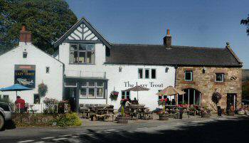
There was a small church built at Meerbrook before the Dissolution of the Monasteries in 1538. The present parish church of St Matthew was erected in two phases in 1870 and 1873. The Lazy Trout is a popular village pub, where you can dine both inside and out in the beautiful rear gardens which have a superb view of the Roaches.
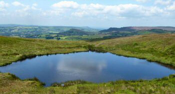
MERMAID POOL (six miles northwest of Leek off the A52 Leek to Buxton Road, northeast of Thorncliffe – SK038605)
The ridgeway across Morridge is a very ancient highway and may date back to pre-historic days. Near the western end and quite close to the road lies Blakemere Pool, better known as Mermaid Pool. In years gone by it was believed to be bottomless and the home of a mermaid who would beckon weary travellers to their death in the dark waters of the pond. There are several stories as to how the mermaid came into existence. One tells how a fair-haired young lady had been drowned in the pond as a witch. Where the local witch-finder who had condemned her to her fate also met a gruesome end. When he was found drowned in the pond with scratches on his face.
The Mermaid Inn stands close to the pool and would have been a welcome sight to weary travellers in bygone days. Today, the impressive 17th-century inn, which stands 1600 feet above sea level and has breathtaking panoramic views, is a popular spot for visitors to stay. It has been refurbished to a very high standard.
MILLDALE (off the A515 Ashbourne to Buxton road – SK139548)
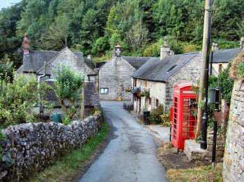
Milldale is a delightfully positioned hamlet at the northern end of Dovedale. It attracts walkers like few other places of its size in Britain. Most come to explore the beautiful Dove Valley, with its steep-sided limestone sides and tree-covered slopes along the stretch that runs from Milldale, down to the large car park close to the road linking Ilam and Thorpe. There was a mill in Alstonefield manor in the 13th century. It was presumably situated in the hamlet of Milldale, where records show that a mill existed to the north of Viator’s Bridge by 1775.
MILLDALE – VIATOR’S BRIDGE
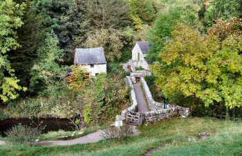
The ancient packhorse bridge, over the River Dove, is the most renowned of all in the Peak District. It was made famous in the English classic The Compleat Angler by Izaak Walton. In the fifth edition, published in 1676, Charles Cotton of nearby Beresford Hall wrote an addendum about fishing, introducing the reader to two travellers – Charles Cotton (Piscator) and Izaak Walton (Viator).
In the days when the two travellers would have approached the narrow bridge at Milldale, it would not have had any walls and must have looked quite frightening to cross. Bridges then were designed with low parapets to allow horses carrying panniers to cross without obstruction. Viator commented on seeing the bridge: ‘Why! A mouse can hardly go over it: ‘tis not twelve fingers broad.’ Milldale Bridge is now known as Viator’s Bridge and its name is clearly in view for all that cross to see.
NEWTOWN (to the east of the B5053 approximately 1.5 miles southwest of Longnor – SK061630)
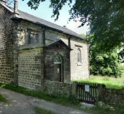
The name is something of a contradiction, Newtown is neither new nor is a town. It is a tiny settlement of scattered farms, barns and cottages in the heather-covered countryside. However, there is evidence that a larger community existed there in former days. The size of the Anglican Church indicates that it was built to serve the needs of a much larger population. It is a Grade II listed building.
ONECOTE (on the B5053, off the A523 Leek to Ashbourne road – SK049551)
Onecote stands mainly on the western side of the Ipstones to Butterton road which crosses the river Hamps by the Jervis Arms whose car park is on the other side of the river. It is a small, pretty village where the houses are mostly built of sandstone that has been quarried locally. The village is surrounded by rolling hills, winding rivers and streams. To the west, there are wonderful views across Morridge Top towards the Roaches, Ramshaw Rocks and Tittesworth. In the other direction, the Manifold Valley is one of Staffordshire’s treasures. St Luke’s Church is at the centre of the village, built in the Georgian style. A new school was built by the local people in 1883. It replaced the one at Loxley Farm but is now closed and fulfils the role of the village hall.
QUARNFORD (off the A53 Leek to Buxton road – SK029683)
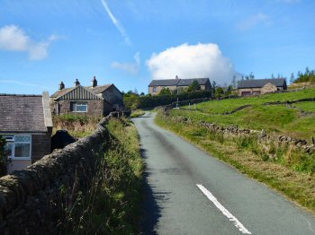
Quarnford is a village and civil parish in the Staffordshire Moorlands District. The village is known by the name Flash but not the parish. It is the highest village in Britain at 1,525 feet above sea level. It is an isolated place, the main part of which consists of well-weathered cottages and a small church, all clustered together seemingly to keep warm on the side of Oliver Hill. There is a public house and café at Flash Bar and a scattering of farms and cottages around the parish.
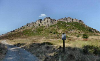
ROACHES (west of the A53 Leek to Buxton road – SK005613)
The Roaches, from the French – les roches – meaning the rocks, together with Hen Cloud and Ramshaw Rocks, form a gritstone escarpment that has been worn into unusual shapes by the weather. They mark the southwestern edge of the Peak District and have panoramic views on a clear day over much of Cheshire and even as far as Snowdon in North Wales.
It is an area of rock and heather, which belonged to the Swythamley Estate before its break up, following which it was purchased in 1980 by the Peak District National Park Authority. From May 2013 Staffordshire Wildlife Trust took on the management of the Roaches Estate, which is enormously popular with walkers, climbers and wildlife enthusiasts.
The area was once famous for its wallabies. These were released in World War II from a private zoo at Swythamley and managed to breed and survive until the late 1990s when the last survivors seemed to have disappeared.
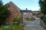
ROCHE GRANGE (approximately one mile north of Meerbrook, west of the A53 Leek to Buxton Road – SK992634}
Roche or Roach Grange is on the site of a medieval grange that belonged to Dieulacres Abbey. The Cistercian Abbey of Dieulacres, which was a substantial producer of wool by the late 13th century, had three granges or sheep farms in the area. A Wesleyan Methodist chapel was opened in Meerbrook in 1862 and was in use until 1992. Before 1862 the Methodists had met at nearby Roche Grange from about 1798. Nothing survives of the Grange.
PART 6 TBA