
Stanshope to Upper Elkstone
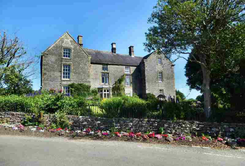
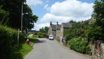
STANSHOPE (between the villages of Ilam and Alstonefield – SK126543)
The tiny hamlet of Stanshope is little more than a cluster of farms dominated by Stanshope Hall. The hall dates back to the 1600s but it has not always been as well kept as it is today. William Manley a moneylender, with two mistresses who lived nearby, went bankrupt in 1799. Over the next 50 years, the house fell into disrepair before being rescued from dereliction in the 1850s. Today, it is a highly regarded hotel. A path from the hotel leads down Hall Dale to Dovedale and the pretty hamlet of Milldale.
SWAINSLEY HALL (between Manifold Way Visitor Centre and Wetton Mill – SK094578)
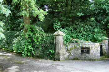
Swainsley Hall was bought by Thomas Wardle in 1896. He made his fortune from silk dyeing and printing on silk at his factories in Leek. It was used as a weekend house as it was too small to accommodate his large family. Shortly after it had been purchased, he had it extended. Thomas loved his time at Swainsley and entertained his quests there, who included Samuel Langhorne Clemens (the writer, Mark Twain), General Sir Robert Baden-Powell and many others. One of the rooms in the hall was used to exhibit drawings and prints by the artist Rossetti. His large collection of trophies from his time in India was displayed in other rooms. He was a keen sportsman and spent many hours fishing and shooting with his friends. After Thomas died in 1909, ownership remained in the hands of his family and for a time the hall was used as a hotel.
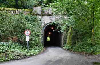
SWAINSLEY TUNNEL (between Manifold Way Visitor Centre and Wetton Mill – SK094578) SK
Swainsley Tunnel was originally built for the Leek and Manifold Valley Light Railway at the behest of Sir Thomas Wardle, director of the company so that the view from nearby Swainsley Hall would not be spoilt and the railway noise and fumes kept away. A single-track ran through the tunnel, which is 164 yards long and is now part of the Manifold Way. Several pedestrian refuges were built into the sidewalls, to enable walkers to get out of the way of traffic using the tunnel. It can be quite busy at weekends and during peak holiday periods.
SWYTHAMLEY (between the A523 Leek to Macclesfield Road and the A54 Buxton to Congleton Road – SK973647)
Swythamley lies in beautiful countryside on the Staffordshire side of the River Dane. Swythamley Hall dominates a few cottages and farms in the area. Originally, it was a medieval hunting lodge belonging to Dieulacres Abbey. It had several owners before, in 1832, it was bought by John Brocklehurst. The Brocklehurst family then set about extending the house. Unfortunately, the original house burned down in 1813 but was soon rebuilt. In 1975, the 2nd Baronet Philip Lee Brocklehurst died, the house was sold and the estate was broken up. For ten years the hall was occupied as a Transcendental Meditation training centre before in 1987 it was sold for residential redevelopment. The Grade II listed coach house was converted for residential purposes as was the private chapel.
The Hanging Stone, a famous landmark, in the Dane Valley bears a plaque to Colonel Henry Courtney Brocklehurst, who died on active service in Burma in 1942. He had previously served as a game warden in Sudan and on his return to England. He set up a private zoo at Swythamley. As the food for the animals ran out during the Second World War, they were released into the surrounding countryside. The wallabies survived and bred around the nearby Roaches until the late 1990s.
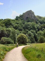
THOR’S CAVE (off the Manifold Way between Wetton to Grindon road and Wetton to Butterton road)
Thor’s Cave is an awesome site. A footbridge and a steep and sometimes slippery climb take you up to the cave from the valley floor. The cave can be seen from a distance and is one of Staffordshire’s most important viewpoints. Samuel Carrington, the Wetton schoolmaster, excavated it in the 19th century when he discovered many relics of prehistoric man. Lower down the cliff are several small caves just above water level. Near the cave is an area used by rock climbers. Some of the climbs are officially rated – very severe. It also has been used as the location for several films, including the 1988 film, The Lair of the White Worm, directed by Ken Russell and starring Hugh Grant.
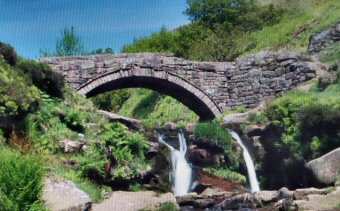
THREE SHIRES HEAD (off the A53 Leek to Buxton road one and a half miles northwest of Flash – SK009685)
Only a short distance from Flash is Three Shires Head, where Panniers Pool Bridge crosses the River Dane at a point where the borders of Derbyshire, Staffordshire and Cheshire meet. Many years ago, illegal prizefights used to take place there, as the police were not allowed to cross county borders, and it was easy for the wrongdoers to flee into another county. For the very same reason, counterfeiters choose the spot for their unlawful trade, ‘flash’ is the name given to the illegal money. The word flash has since become associated with being dishonest, or for goods not of genuine quality.
THROWLEY (approximately one-mile northwest of Ilam – SK110526)
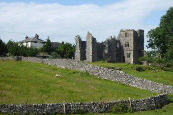
Throwley was first listed as a residence when Oliver de Meverell took up residence in 1203. But the area was inhabited long before that. Archaeological relics have been found At Thor’s Cave and burial grounds at Casterne. Traces of a medieval village have been found near the hall. The old hall, now in ruins, is Staffordshire’s only surviving example of a large medieval manor house.
Nearby, Casterne Hall is a privately owned 18th-century country house. It is Grade II* listed. It was partially rebuilt in 1740 by Nicholas Hurt, who became High Sheriff of Derbyshire in 1756. The present-day three-story, five-bayed entrance front is Georgian style and dates from that period. The house has been featured in several films including Jane Eyre, The Hound of the Baskervilles and Far from the Madding Crowd.
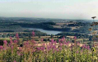
TITESWORTH RESERVOIR (off the A3 Leek to Buxton road near Merebrook village – SK989608)
Part of the village of Meerbrook was lost in the 1950s when Tittesworth Reservoir was extended. Originally a reservoir was built by the Staffordshire Potteries Waterworks Company in 1858, as a compensation reservoir to regulate the flow of water in the River Churnet, which was used by several mills downstream. Today, the reservoir and the associated water treatment works are owned and operated by Severn Trent Water.
The area with its beautiful scenery is popular with walkers, who can choose between a gentle walk around the reservoir or a more strenuous hike up to the Roaches which tower above the reservoir. As well as with those who just want to sit and relax at the visitor centre or by the shoreline of the reservoir and watch the water sports enthusiasts enjoying themselves.
Tittesworth Reservoir is the second largest reservoir by volume in Staffordshire and the Peak District Boundary Walk runs past the reservoir.
UPPER ELKSTONE (2 miles west of Warslow – SK057690)
Elkstone is now part of Staffordshire Moorlands district and comprises two farming hamlets. Somewhat off the beaten track Upper Elkstone has some attractive cottages with lovely gardens and a few isolated farms. Sheltered to the west by the moorland ridge of Morridge, it is frequently visited by moorland walkers. A chapel at Elkstone was recorded in 1524. It probably stood at Upper Elkstone, where there was a church in 1682. The present-day church of St John the Baptist at Upper Elkstone was built in the 1780s. It remains largely unaltered and is Grade II* listed.
Signs of early habitation in the area still exist in the form of three Bronze Age barrows on the top of a hill to the southwest of Upper Elkstone.
PART 7