ST PETER’S STREET
St Peter’s Street developed along the historic north-to-south route. This connected the street with the marketplace, after crossing the bridge over Markeaton Brook. Originally the parishes of St Peter’s and All Saints’ played football at Shrovetide. A French prisoner of war once said about the game, ‘If the English call this playing, it would be impossible to say what they call fighting.’ The game has been abolished, but Ashbourne continues the tradition.
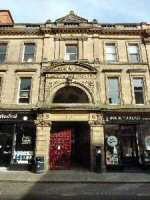
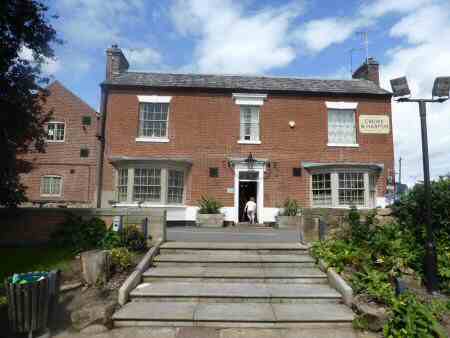
ST PETER’S STREET – BABINGTON BUILDINGS
Babington Buildings were designed by Methodist chapel architect John Wills for Hull-born entrepreneur Councillor G E Franklin. He was the proprietor of a national footwear chain called the Public Benefit Boot and Shoe Company. It had its branch on the ground floor and rented out the upper floors. High up at the front of the building are two baboons carved on either side of a barrel or tun – ‘baboon-tun’. This is interpreted as Babington.
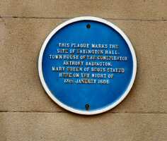
ST PETER’S STREET – BABINGTON HALL PLAQUE
A plaque on the wall of the NatWest Bank marks the site of Babington Hall. Where Mary Queen of Scots was detained in Derby in 1585. Anthony Babington had acted as her page and supported her cause. In 1586, he was persuaded to take a leading role in a plot to assassinate Queen Elizabeth and place Mary on the throne. As a result, both he and Mary were executed.
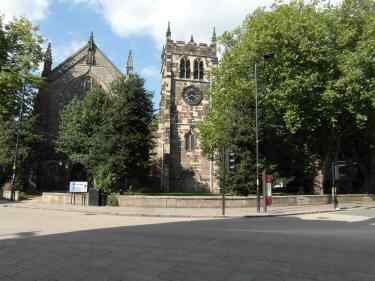
ST PETER’S STREET – OLD BOOTS BUILDINGS
The Old Boots Building now the home of Costa Coffee was originally occupied by Boots the Chemists. It is an Arts-and-Crafts designed building by Albert Bromley and is one of the city’s most appealing buildings. What particularly draws attention are the four small statues in niches spaced out above the shop frontage of Florence Nightingale, John Lombe, William Hutton and Jedediah Strutt.


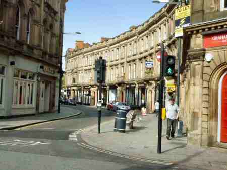
THE STRAND
The Strand came into existence when the decision was made to culvert Markeaton Brook from Sadler Gate Bridge to St James’ Bridge. Sir Abraham Woodiwiss, who was Mayor of Derby from 1880-82, built the Strand including the Strand Arcade and parts of St James’s Street in 1878-81 as a commercial venture. The graceful curve of the building frontages, the balustrade entrances, the highly decorated stonework and the neatly arranged windows create considerable interest.
STRAND ARCADE
Victorian Strand Arcade was created in the early 1870s from designs by John Story. It was designed to replicate London’s Burlington Arcade. It links Sadler Gate and the Strand and has been described as a unique link between different ages and city cultures. Sadler Gate on its way down from Iron Gate twists and turns informally which contrasts with the formal appearance of the Strand Arcade with its tall and impressive three-storey entrance off Sadler Gate.
SWARKESTONE
This small, quiet South Derbyshire village with a population of less than 200 is set on the banks of the River Trent. Over 275 years ago it was the scene of one of the most momentous incidents in English history, often referred to as the ‘45’. From the time when James II, the last Stuart King of England went into exile in France in 1688, the Jacobites had attempted several times to regain the throne. All had failed and in 1745, it was the turn of Prince Charles Edward Stuart, frequently known as Bonnie Prince Charlie, to try to overthrow the English Monarch. Support for the cause was half-hearted, but enough clansmen were raised for the march south. The English were unprepared for an invasion, most of the troops were abroad and King George, fearing the worst, was preparing to return to Germany.
On 4 December 1745, Charles Edward Stuart and his army reached Derby and planned for the capture of the strategically important Swarkestone Bridge. It was the only bridge on the River Trent, between Burton and Nottingham. Charles and his supporters were unaware of the panic the uprising had created in London and with no signs of help coming from France or a revolt in support of the campaign. A meeting was held at Exeter House in Derby, when the Jacobite generals decided to retreat, despite the protestations of their leader. If the march had continued, it would probably have been successful and the whole course of British history changed. In memory of this important event, a cairn has been erected at Swarkestone Bridge, in the gardens of the Crewe and Harpur Arms. It marks the southernmost point reached by an advanced party of Bonnie Prince Charlie’s army.
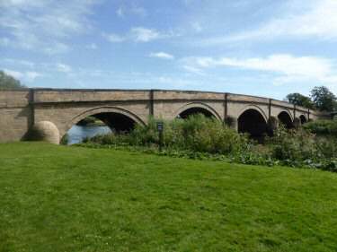
SWARKESTONE BRIDGE AND CAUSEWAY
At a length of three-quarters of a mile, it is the longest stone bridge in England and holds Grade I listed building status. There has been a bridge here for 800 years, and at one time a bridge chapel and toll house stood partway across the bridge. It is still an important crossing place and has become increasingly busy with traffic. The narrowness of the bridge has led to frequent accidents.
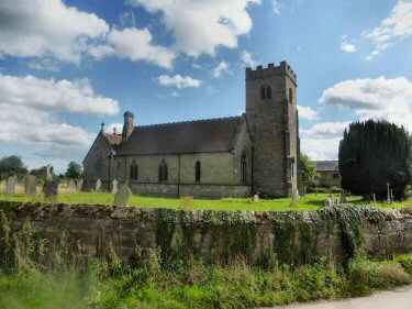
SWARKESTONE – ST JAMES’ CHURCH
The tiny St James’ Church contains some superb carvings. Sir Richard Harpur, who was one of Queen Elizabeth’s judges, lies in his judge’s gown, on a fine alabaster tomb, with his wife Jane. They both lived at Swarkestone Hall. Little remains of the hall today, but the Old Hall Farm, built out of part of its remains still exists.
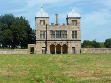
SWARKESTONE SUMMER HOUSE
The most unusual building in the village is the Summer House, sometimes called ‘The Grandstand’. It has a grass-covered rectangular enclosure in front. No one is quite sure what its use was; bull-baiting and jousting are suggestions. More likely, the much gentler pursuit of bowling took place there. It is now in the hands of Landmark Trust and is let for holiday accommodation.
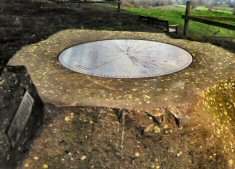
MILLENNIUM TOPOGRAPH
Located on Bunkers Hill at Quarndon, the directional compass provides details of bearings, distances, elevations and dates of nearly 50 places of special interest. It was unveiled on 29 September 2001 and stands on an 8-ton block of Derbyshire gritstone. The topograph was funded by the will of the third Viscount Scarsdale who died in 2000 aged 76.